Posts

Showing posts from 2018

Coffs Harbour - 30° 18' 15" S 153° 08' 49" E

Image
Riding the EAC! Remember in 'Finding Nemo' when Dory and Marlin used the EAC Superhighway with the turtles to get to Sydney? We did it too - although perhaps not quite the same speed and minus the turtles! The EAC is the East Australian Current that runs down the east coast of Australia.  Somewhat larger than the film portrayed, the EAC is a surface current that is up to 100km wide in places.  It is strongest in the Summer and runs up to 4kns.  We picked it up off the coast of Fraser Island and held on for the ride! The East Australian Current Steaming past Brisbane - 9.6kn over ground  with a little help from the EAC! We experienced its gentle nudge of between 2.5 and 3.5kn.  For a period, we has 4.1kn of current helping us along.  To put this in perspective, each knot of additional speed on a 24 hour passage saves around 3-4 hours.  So that's awfully nice! 4.1kns - thats a nice little nudge! Weeeee - we love the EAC! 'You'...

Whitehaven Beach - 20° 17' 30" S 149° 03' 21" E

Image
Whitehaven Beach Beautiful Whitehaven Beach with sand like icing sugar and azure waters, it listed as one of the top ten beaches in the world by Lonely Planet. Somewhat subjective, some will debate, but there is little argument that Whitehaven is stunning. ...and accessible. Hoards of tourists flock to the southern end of the beach by helicopter, sea-plane, yacht and power boat, charter boat and fully-loaded day tour boats that purge tourists reminiscent to the wartime landings in Normandy. Yet despite this, Whitehaven remains stunning.  Anchor a tad further north and all but the most intrepid tourist can be avoided. The warm, clear waters invite swimming and the bright, white sand is perfect for lazing. A wonderful place to spend a day or two! ...but Lonely Planet, did you really have to tell the whole world?!

Cid Harbour - 20° 15’ 43” S 148° 56’ 23” E

Image
Paradise with sharp teeth Cid Harbour Cid Harbour in The Whitsunday Islands is picture perfect. The water is that stunning shade of turquoise that has you questioning; blue? green?   It is prime cruising season with dozens of yachts bobbing at anchor on the sparkling water.   The weather is sunny and warm.   Dinghies zip around the bay and the sounds of splashing and laughter carry across the water as people leap from their boats into the sparkling, warm turquoise.    We swam off Popeye, floating and splashing and practicing the backward roll method of getting into the dinghy.   We took the dinghy ashore, wandered along the beach and hiked the track around the headland.   We watched the turtles frolic, completely nonplussed by our presence.   And then we jumped into that magical warm water to rid ourselves of the sweat of the tropical day. We had just settled in for sundowners with a glass of wine in hand ...

Cycling Alsace - 48° 27' 44" N 07° 28' 59" E

Image
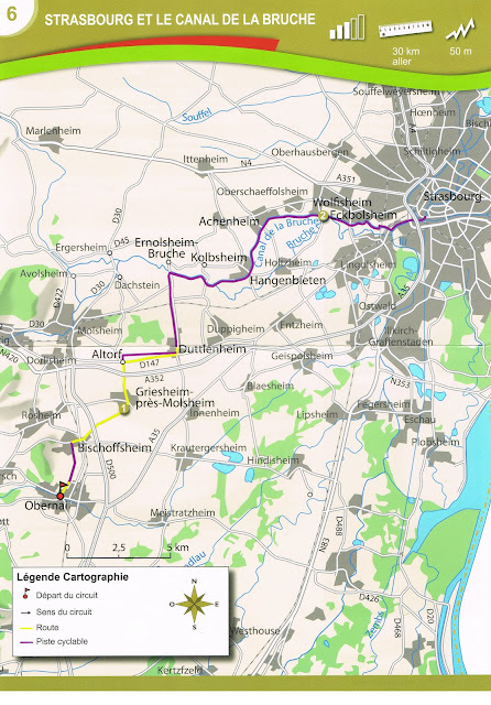
We first brought our bikes to Alsace in 2012 and immediately feel in love with the cycling here.  Head east, and you ride the flats of the Rhine Valley, through crops of corn, wheat, cabbages and barley and along canals dotted with locks and white swans.  Head west, and it is the hilly terrain of The Vosges Mountains with castle ruins, forests and steep climbs.  North and south, you can choose climbs, flats or the rolling hills through the vineyards of the Route des Vins. The cycling infrastructure has improved over the last six years.  When we first came, the signage simply directed you to the next village so you had to know each and every small town along the route.  With the villages being only 3 - 4km apart, this was a challenge!  The signage has improved with the use of numbered cycling routes from local loops and the wine routes, up to the EuroVelo #5 which runs 3,300km from London, England to Brindisi, Italy! The Tourist Offices in the region ren...

Running Norway - above 59° 54' 52" N east of 05° 19' 24" E

Image
With Susan in training for a half marathon, running became part of our sightseeing plans! A fabulous way to see the cities of Oslo and Bergen in the quiet of the mornings before the hoards of tour buses arrived.  Running on our Hurtigruten stops helped burn off some of the food we were eating and allowed us greater range in the short time frames of the stops.  And, of course, running under the midnight sun (and the blood moon) at 12:30am in Trømso was very cool! Add caption Oslo - between 5-7km each morning exploring different parts of the city Bergen - 5km most mornings with a hike up the hill one day Ålesund - a speedy 5km along the river Trondheim - 10km under picture perfect blue sky Svolvær - 5km, or was that 3km?! Kirkenes - 5km in the pouring rain.  Our only true rain day! Trømso - 10km under the midnight sun and the blood moon (very cool!) Brønnøysund - 5km with lots of groaning Trondheim - 10km with aching legs  Florø - short, gotta ...

Nordkapp (North Cape) - 71°10′21″N 25°47′04″E

Image
Well this is a long way north... The most northern point in Europe!  ...well, not quite. That would be an island well north of here. The most northern point of mainland Europe? Nope, as it is on an island it cannot be!  That honour goes to Kinnarodden ( Cape Nordkinn) a little further to the east.  (We did sail around this so we can claim to have passed the northernmost point of mainland Europe!).  Kinnarodden is remote and difficult to get to, requiring a full day's hike each way over some fairly gnarly terrain The most northern point of Europe accessible by road (read tourist bus)? YES!! So we intrepidly rode the bus to the over touristy Nordkapp - the northernmost point of Europe accessible by road!  We were fortunate to arrive at a time when the weather was clear and the tourist buses few... At 'The Top Of Europe' We can almost see the North Pole from here! Wild and windy The Most Northermost Point in Europe (that can be access...

Polarserkel (The Arctic Circle) - 66 33' 00" N 13' 02.196" E

Image
The Arctic Circle, that circle of latitude that marks the southern most point of the polar night of the winter solstice and the polar day of the summer.  Its actual latitude does vary due to the Earth's wobble but it is at roughly 66 33' N.  And we crossed it! We are close enough to the summer solstice to experience the 'midnight sun', the endless day that the Arctic enjoys. Yay for our windowless cabins! Crossing the Arctic Circle Yep, midnight and it's still light And the certificate to prove it! The midnight sun 'Sunrise' in Trømso Running at 1am!

Aboard the MS Lofoten - 66 04' 48" N 12 40' 44" E

Image
The next leg of our trip is a voyage on the Hurtigrtuen Coastal Ferry, the MS Lofoten, from Bergen to Kirkenes and back to Bergen. Travelling through the famed fjords, across the Arctic Circle and over the top of Europe to the end of Norway and back! MS Lofoten is a grand old girl, the oldest and the smallest ferry in the Hurtigruten fleet. Along with the 100 'cruising' passengers, the ferry carries cargo and up to 300 day passengers stopping at 36 ports, towns and villages along the 2500nm journey. Ruteplan - Bergen to Kirkenes and back! Our cabins are on C-deck, in the bowels of the ship well away from the engine noise, the flushing of the shared toilets and the clatter of day passengers. Our inside cabins are wonderfully dark for sound sleeping during the endless daytime of the Arctic north. Cabin 103 - remarkably roomy The meals on board are plentiful and delicious. Breakfast and lunch are a buffet and, with a nod to its 1960s heritage, dinner is a set menu with...