Monday, October 19, 2020

Time Zones, Meridians and the Longitudinal Centre of Canada - 49° 44' 29" N 96° 48' 35" W

According to worldwide standard time, there are six time zones in Canada - Pacific, Mountain, Central, Eastern, Atlantic and Newfoundland.  We live on the western edge of Mountain Time and we expected to lose an hour as we crossed into Manitoba (Central) then again as we approached Thunder Bay (Eastern) in Ontario.  Things appeared so orderly and simple.

No so fast...  

Canadian Time Zones as they really are!

Saskatchewan is Central Time (except for Lloydminister which is on Mountain Time) but choses not to observe daylight savings, so in the summer they line up with Mountain Time.  Manitoba is on Central Time but observes daylight savings. Western Ontario (west of 90°) is on Central Time and observes daylight savings, except the Atikokan and Pickle Lake areas.  They run on Eastern Standard Time year round.  Ontario (east of 90°) and Québec observe Eastern Time.  Oh, except for Québec east of the Natashquan River.  They observe Atlantic Standard Time year round. 

Phew.  Confused yet?  

So were we - and so was the GPS in our car.  Our phones, watches and car clock were often out of sync.  And we could not look skyward to judge the sun's angle to approximate the time as there is a big issue with the time of sunrise and sunset due to the size of some time zones.  The Eastern Time Zone is huge.  It is 2,500km from Thunder Bay to Gaspé.  The sunrise and sunset in Thunder Bay is an hour and three-quarters later than in Gaspé. So the sun rises at 6:45am in Gaspé but not until 8:20am in Thunder Bay.  No wonder we never knew what time is was!  

And it was a Canadian who gave us worldwide standard time - Sir Stanford Fleming! Now Sir Stan was a bit of a legend. Not only did he come up with the idea of time zones linked to the Prime Meridian, he designed Canada's first stamp, proposed the use of 24-hour time and engineered much of the Canadian Pacific Railway - and that was only in the first half of his life.  Quite the overachiever!  

The Meridians of Western Canada

So let's talk meridians.  They are very important in Western Canada.  When carving up the west to provide land grants to settlers (and in the process, breach the treaties and generally screw over the First Nations and Métis), The Dominion Land Survey created a series of meridians.  These are lines of longitude running between latitudes of 49° N and 60° N. The first meridian is at 97° 27' 28.4" W,  just to the west of Winnipeg and chosen because it was the extent of settlement at the time.  In creating the next six meridians, things became a little more orderly and the second meridian was established at 102°W.  Subsequent meridians are every 4° of longitude until the Seventh Meridian at 122°W.  


The Fourth Meridian, which establishes the border between Saskatchewan and Alberta is the world's longest surveyed straight line!  A definite need of a plaque for that!

Oh look! A Plaque...

Another point of interest is the Longitudinal Centre of Canada - the line midway between the extreme east and west of Canada - is at 96° 48' 35" or just east of Winnipeg on Highway 1.  The actual centre of Canada is 1 500km further north at 62° 24' 0" N 96° 28' 0" W.


Tuesday, October 13, 2020

Roadside Attractions of Canada - 49° 42' 00" N 96° 48' 35" W

If you are driving across hundreds and HUNDREDS of kilometres of countryside, it is very easy to whiz through the little towns and villages that lay strewn along your path.  The merchants of the petrol stations and lunch counters would prefer you to stop and toss a few sheckles their way, but what could tear your attention away from that endless dotted line that beckons you into the distance?  How about some of these things that we found?


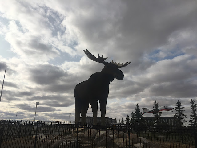
8 metre tall moose statue,
Moose Jaw, Saskatchewan

Reginald, the giant grasshopper. 
Because everyone in Saskatchewan loves locusts.
Regina, Saskatchewan

At the tourist info centre in ...
(you guessed it) Indian Head, Saskatchewan.

Lumberjack.
Iroquois Falls, Ontario.


Spaceship with aliens looking out of the bottom portholes.
Moonbeam, Ontario.

The Big Loonie in Echo Bay, Ontario.  A huge display that
honors the most famous son of Echo Bay - Robert-Ralph Carmichael,
the designer of the Loonie.

Impressive statue for a village of 648 people.
Mattice-val-Coté, Quebec

Statue of Wolves About to Kill Two Moose
Hearst, Ontario 

Terrifying concept but great execution.
Beardmore, Ontario

Giant Snowman.
Beardmore, Ontario


There was no provincial dividing line on the country road
we used to traverse from Manitoba to Saskatchewan, so I made one.


The Big Nickel.
Sudbury, Ontario

Extra style points for saving this SUBMARINE from being cut into scrap metal
and somehow beaching it.
Pointe-au-Peré, Quebec

Paddle-To-The-Sea monument.
Nipigon, Ontario

Not sure who is more manic looking.
The World's Largest Free-Standing Banana.
Melita, Saskatchewan  

The most forlorn-looking Mountie.
Redvers, Saskatchewan

The Big Goose.
Wawa, Ontario

A big, empty field ... except for this.


Honorable Mention: Bathtub Marys
These do the lawns of small Roman Catholic towns of Quebec.  These shrines are so named
as they are often former bathtubs from old farmhouses that have been entombed in brick,
rock and mortar and have a saint or apostle on display inside.
 

Monday, October 5, 2020

Lac de la Tonne - 49° 04' 56" N, 65° 54' 53" W

A birthday misadventure!

We packed up our camp in the beautiful Forillon National Park and, being able to go no further east, we started our journey back towards Canmore.  We drove along the north coast of the Gaspé Peninsula along road protected by a seawall against the worst the St Lawrence could throw at it.  And birds, birds everywhere.  Those you expect to see and others I am not used to seeing bobbing on the ocean such as mallard ducks...

Although the weather was getting chillier and car camping less inviting, on impulse we decided to drive through Parc national de la Gaspésie and Resérve faunique des Chic-Chocs and wild camp for just one night.  The weather was overcast and threatening rain, the autumn colour was finished and there was the chill of winter in the air.  The landscape was hilly and with many small lakes dotted around.

Lac de la Tonne - looks like a lovely place to camp!

Around 4pm, we were about an hour from the main road and decided to find a lake to camp on and enjoy a birthday drink.  Lac de la Tonne fitted the bill perfectly and had a road down to the lakeside.  We decided to back down, raise the hatch, sit and enjoy the evening.  

Not our finest hour...

... and beautiful view for a birthday drink!

Our track out -
much worse than it looks


Front-wheel drive, a heavily-loaded car on slick summer tyres, no cell coverage and no-one knew where we were ... so of course we got bogged.  The next 45 minutes involved a lot of grunting, pushing, head scratching, internal panic and stuffing things under wheels - darkness falling and spitting rain the whole time.

Finally, after unloading the weight out of the back of the car and finding a stout limb to use as a lever, we managed to inch the car forward and with an almighty rush of relief, the tyre caught and the car pulled itself up the rise.  Jeez did we need a drink!

We were too flustered to snap photos of the car slipping and sliding on the mud.   But as you can see, it wasn't particularly steep, an incline at best - but just enough!


near-panic- skid marks


With the car safely parked at the very top of the path with wheels on the gravel road, we took our lawn chairs back to the lake and enjoyed a beer until the rain started coming down. Our relief was immense with each of us staying outwardly calm. We both confessed to internal panic and were imagining riding our bikes back to the main road to get help.  We were VERY careful to make sure we had the car keys.


Was it an adventure or a harrowing episode averted?  Is there a difference?