Thursday, November 26, 2020

Lac des Arcs - 51° 03' 08" N 115° 10' 19" W
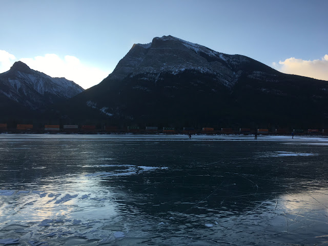

It's known locally as Wild Ice. It is a phenomena that occurs for only a few days a year, early in the winter.  It is when we have a sustained deep dip in temperatures as winter approaches, causing lakes to freeze before the first snow fall, thick and safe enough to skate on.  From a distance, it looks like water with the surrounding mountains reflecting on the ice.

This year we had that cold snap, so a flurry of posts to the local Facebook group began to appear, as anticipated as the first few kernels of popcorn on a saucepan over a fire.

"Get your skates sharpened.  It's at least 8 cm think at Gap Lake."

"Has anyone tested Lac Des Arc?"

When we felt it was safe (because those who are too keen and too early can and sometimes do fall through), we made arrangements to meet Rick and Sue early, while the morning air still held some bite.  The days are getting noticeably shorter, making it feel that much more of an intrusion on time that should be spent in bed, or huddled at the kitchen table with both hands wrapped around a warm first mug o' tea.  Driving along the secondary highway, the one that doesn't carry all the tourist traffic, with headlights still necessary to the agreed-upon meeting place, we pull into the deserted parking lot and kill the engine.  From the back of the van we remove the bag of skates, the hockey sticks and a milk crate to sit on at the water's (ice, really) edge.  

Rick and Sue are only a few minutes behind us.  We strategize about where to plop ourselves and equipment so as not to damage the skate blades by using them to wobble over rocks and to not have to penguin-walk too far in our shoes on slippery ice.  Although the sky above us is now light, we will still feel cloaked in darkness until the sun makes it's way above the peaks that create the Bow valley and it's not-warm-enough beams reach us.

Kate on Gap Lake


It is a magical feeling skating across a lake.  Through the ice you can see the lake bed - rocks, mud, weeds and sometimes, the odd fish.  The ice doesn't freeze exactly smooth and the imperfections cause a bumpity-bump feeling as you glide along.  Moving away from shore feels odd and an on-shore breeze holds us back more than you think it should.  Our legs feel stiff and heavy to start with, for the first twenty or thirty strides.  As we get further out, muscle memory takes over and we are able to take longer, smoother glides.  There is hardly anyone else on the whole lake and we feel very alive and humble and in awe of the beauty of this little nook in the mountains.


Feeling very Canadian at Lac des Arcs


This part of Canada is a wondrous place - and not just in the middle of summer.

Thursday, November 12, 2020

Canmore Nordic Centre - 51° 5' 25" N 115° 23' 16" W

At the moment, Huntsville, Ontario is snowless and it has ended up benefitting us.  

In September, Kate had noticed a posting on a Canmore facebook group that was looking for someone to billet two athletes who wanted to get an early start to their cross country skiing training.  As we live just down the road from the Nordic Centre (where athletes from all over Canada come to kick and glide over 110 kilometres of well-groomed trails) and no prospect of visitors to occupy our two guest bedrooms, we offered to take in these unknown teenagers.

Several e-mails, phone calls and text messages later, we were primed to expect a 15- and 17-year-old from an area we had just visited in September.

Sophie and Mya at the Nordic Centre

Having Mya and Sophie has been delightful.  Enthusiastic, helpful and good company, Kate and I are very much enjoying their company.  They both train very hard - working out 3 - 4 hours a day.  Although they have prescribed workouts from their coach in Ontario, they are self-motivated and manage their schoolwork, music practice (Mya plays the flute) and dryland and ski training with no nagging or reminding required on our part.  They proven they can both eat like true athletes, contrary to their visible lack of body fat.  Kate, acting as a surrogate-Italian mama, plies them with overflowing bowls of dinner which they happily plow through.

They always seemed to have something to do and Kate and I appreciated having them around to occupy our COVID-restricted time and attention.  Even though the Nordic Centre is very close (as the crow flies), we offered to drive them when they needed to get there as it was pretty much uphill the whole way.  When the girls weren't training, they were always keen to tag along on our adventures.  We managed to get to Lake Louise for two days of recreational cross-country skiing.  We did a hike up Sulphur Mountain and happily rode the gondola down - no charge for us locals and our "kids."  We did a few pizza nights, sing-a-long nights and although we didn't socialize with anyone outside the house, we had lots of fun as a group.

Top of Sulphur Mountain - great weather!

Being good billetters, we are helping them with homework when we can.  One of Sophie's homework assignments was to identify and gauge the mood of music played in the soundtrack of Lord of the Rings.  As Fellowship of the Rings was available on Netflix, we decided to make it a movie night.  As the credits started to roll, Kate quipped, "... and that's it?!?" She didn't realize that the movie we had just watched was one of THREE.  Luckily, we had two more nights before they had to head home and dedicated ourselves to getting through all eleven hours of cinema before they had to go back to Ontario.

We now have a reason to keep up with the Ontario Cross-Country Age Group standings.

GO SOPHIE!  GO MYA!  GO TEAM MARSHALL!

We were happy to have you stay with us and you are welcome back any time.  Just give us some warning so we can have enough groceries in the fridge.  

Monday, October 19, 2020

Time Zones, Meridians and the Longitudinal Centre of Canada - 49° 44' 29" N 96° 48' 35" W

According to worldwide standard time, there are six time zones in Canada - Pacific, Mountain, Central, Eastern, Atlantic and Newfoundland.  We live on the western edge of Mountain Time and we expected to lose an hour as we crossed into Manitoba (Central) then again as we approached Thunder Bay (Eastern) in Ontario.  Things appeared so orderly and simple.

No so fast...  

Canadian Time Zones as they really are!

Saskatchewan is Central Time (except for Lloydminister which is on Mountain Time) but choses not to observe daylight savings, so in the summer they line up with Mountain Time.  Manitoba is on Central Time but observes daylight savings. Western Ontario (west of 90°) is on Central Time and observes daylight savings, except the Atikokan and Pickle Lake areas.  They run on Eastern Standard Time year round.  Ontario (east of 90°) and Québec observe Eastern Time.  Oh, except for Québec east of the Natashquan River.  They observe Atlantic Standard Time year round. 

Phew.  Confused yet?  

So were we - and so was the GPS in our car.  Our phones, watches and car clock were often out of sync.  And we could not look skyward to judge the sun's angle to approximate the time as there is a big issue with the time of sunrise and sunset due to the size of some time zones.  The Eastern Time Zone is huge.  It is 2,500km from Thunder Bay to Gaspé.  The sunrise and sunset in Thunder Bay is an hour and three-quarters later than in Gaspé. So the sun rises at 6:45am in Gaspé but not until 8:20am in Thunder Bay.  No wonder we never knew what time is was!  

And it was a Canadian who gave us worldwide standard time - Sir Stanford Fleming! Now Sir Stan was a bit of a legend. Not only did he come up with the idea of time zones linked to the Prime Meridian, he designed Canada's first stamp, proposed the use of 24-hour time and engineered much of the Canadian Pacific Railway - and that was only in the first half of his life.  Quite the overachiever!  

The Meridians of Western Canada

So let's talk meridians.  They are very important in Western Canada.  When carving up the west to provide land grants to settlers (and in the process, breach the treaties and generally screw over the First Nations and Métis), The Dominion Land Survey created a series of meridians.  These are lines of longitude running between latitudes of 49° N and 60° N. The first meridian is at 97° 27' 28.4" W,  just to the west of Winnipeg and chosen because it was the extent of settlement at the time.  In creating the next six meridians, things became a little more orderly and the second meridian was established at 102°W.  Subsequent meridians are every 4° of longitude until the Seventh Meridian at 122°W.  


The Fourth Meridian, which establishes the border between Saskatchewan and Alberta is the world's longest surveyed straight line!  A definite need of a plaque for that!

Oh look! A Plaque...

Another point of interest is the Longitudinal Centre of Canada - the line midway between the extreme east and west of Canada - is at 96° 48' 35" or just east of Winnipeg on Highway 1.  The actual centre of Canada is 1 500km further north at 62° 24' 0" N 96° 28' 0" W.


Tuesday, October 13, 2020

Roadside Attractions of Canada - 49° 42' 00" N 96° 48' 35" W

If you are driving across hundreds and HUNDREDS of kilometres of countryside, it is very easy to whiz through the little towns and villages that lay strewn along your path.  The merchants of the petrol stations and lunch counters would prefer you to stop and toss a few sheckles their way, but what could tear your attention away from that endless dotted line that beckons you into the distance?  How about some of these things that we found?


8 metre tall moose statue,
Moose Jaw, Saskatchewan

Reginald, the giant grasshopper. 
Because everyone in Saskatchewan loves locusts.
Regina, Saskatchewan

At the tourist info centre in ...
(you guessed it) Indian Head, Saskatchewan.

Lumberjack.
Iroquois Falls, Ontario.


Spaceship with aliens looking out of the bottom portholes.
Moonbeam, Ontario.

The Big Loonie in Echo Bay, Ontario.  A huge display that
honors the most famous son of Echo Bay - Robert-Ralph Carmichael,
the designer of the Loonie.

Impressive statue for a village of 648 people.
Mattice-val-Coté, Quebec

Statue of Wolves About to Kill Two Moose
Hearst, Ontario 

Terrifying concept but great execution.
Beardmore, Ontario

Giant Snowman.
Beardmore, Ontario


There was no provincial dividing line on the country road
we used to traverse from Manitoba to Saskatchewan, so I made one.


The Big Nickel.
Sudbury, Ontario

Extra style points for saving this SUBMARINE from being cut into scrap metal
and somehow beaching it.
Pointe-au-Peré, Quebec

Paddle-To-The-Sea monument.
Nipigon, Ontario

Not sure who is more manic looking.
The World's Largest Free-Standing Banana.
Melita, Saskatchewan  

The most forlorn-looking Mountie.
Redvers, Saskatchewan

The Big Goose.
Wawa, Ontario

A big, empty field ... except for this.


Honorable Mention: Bathtub Marys
These do the lawns of small Roman Catholic towns of Quebec.  These shrines are so named
as they are often former bathtubs from old farmhouses that have been entombed in brick,
rock and mortar and have a saint or apostle on display inside.
 

Monday, October 5, 2020

Lac de la Tonne - 49° 04' 56" N, 65° 54' 53" W

A birthday misadventure!

We packed up our camp in the beautiful Forillon National Park and, being able to go no further east, we started our journey back towards Canmore.  We drove along the north coast of the Gaspé Peninsula along road protected by a seawall against the worst the St Lawrence could throw at it.  And birds, birds everywhere.  Those you expect to see and others I am not used to seeing bobbing on the ocean such as mallard ducks...

Although the weather was getting chillier and car camping less inviting, on impulse we decided to drive through Parc national de la Gaspésie and Resérve faunique des Chic-Chocs and wild camp for just one night.  The weather was overcast and threatening rain, the autumn colour was finished and there was the chill of winter in the air.  The landscape was hilly and with many small lakes dotted around.

Lac de la Tonne - looks like a lovely place to camp!

Around 4pm, we were about an hour from the main road and decided to find a lake to camp on and enjoy a birthday drink.  Lac de la Tonne fitted the bill perfectly and had a road down to the lakeside.  We decided to back down, raise the hatch, sit and enjoy the evening.  

Not our finest hour...

... and beautiful view for a birthday drink!

Our track out -
much worse than it looks


Front-wheel drive, a heavily-loaded car on slick summer tyres, no cell coverage and no-one knew where we were ... so of course we got bogged.  The next 45 minutes involved a lot of grunting, pushing, head scratching, internal panic and stuffing things under wheels - darkness falling and spitting rain the whole time.

Finally, after unloading the weight out of the back of the car and finding a stout limb to use as a lever, we managed to inch the car forward and with an almighty rush of relief, the tyre caught and the car pulled itself up the rise.  Jeez did we need a drink!

We were too flustered to snap photos of the car slipping and sliding on the mud.   But as you can see, it wasn't particularly steep, an incline at best - but just enough!


near-panic- skid marks


With the car safely parked at the very top of the path with wheels on the gravel road, we took our lawn chairs back to the lake and enjoyed a beer until the rain started coming down. Our relief was immense with each of us staying outwardly calm. We both confessed to internal panic and were imagining riding our bikes back to the main road to get help.  We were VERY careful to make sure we had the car keys.


Was it an adventure or a harrowing episode averted?  Is there a difference?


Friday, September 11, 2020

Terry Fox Memorial – 48° 29’ 09” N 89° 10’ 11” W


Not far out of Thunder Bay, high on a hill with sweeping views over Lake Superior and the Sleeping Giant, sits the Terry Fox Monument. Just over 40 years ago, Terry Fox was forced to end his Marathon of Hope as the cancer he was fundraising to cure caught up with him.

He was 18 when he lost his leg to cancer and, while in hospital, was dismayed at the amount of suffering the illness caused particularly amongst the kids. So he resolved to run across Canada and raise money toward a cure. This was a new idea and well before all the 'Run for Cures' we do now.  After some training, he dipped his toe in the Atlantic Ocean in St John’s, Newfoundland and commenced his run back to Victoria in BC.

On one leg and a prosthetic that was closer to a wooden stump than the fancy running legs we have today, he ran an average of marathon a day, for 143 days - 3339 MILES (5,373km) in all until he was too sick to continue. His dream was to raise a dollar for every Canadian –the huge sum of about $24 million at the time. He did achieve this prior to his death.


His legacy lives on. The Terry Fox Foundation has raised over $750 million for cancer research. The Terry Fox Run is an annual non-competitive (and non-sponsored) run held in over 40 countries.

I ran 50km in perfect conditions and vowed never to run that distance again! Terry Fox ran an average of 42km a day in all kinds of weather including snow storms and freezing rain - on a prosthetic limb...

It is seriously humbling.

The highway between Thunder Bay and Nipigon is the only road in Canada that connects east to west.  It is quite fittingly named The Terry Fox Courage Highway.

Wednesday, September 9, 2020

A precious gift from a precious friend - 51° 04' 58" N 115° 22' 07" W


Words fail me.

A most amazing gift from my extraordinary friend Rachael.  Understanding my devastation with losing Dad, she made me a memorial quilt - sails, 'three sisters', kangaroos and a touching dedication.

Thank you. I will treasure it forever.


Monday, September 7, 2020

Buffalo Lookout Campground – SK 50° 26' 47" N 104° 26' 51" W

The first night sleeping in the car was supposed to be trouble-free, but ended up with us needing outside help!

We were determined to see how bad it could be sleeping with the ceiling 40 cm away from your face all night ... but in a safe environment.  A test of sleeping in the garage was proposed, so at the end of our day, we donned our jammies and toddled downstairs to the garage.

Bed for the night!


We were both surprised at how comfy the bed was and how well we slept.  There was some initial planning required as we enter and exit bed through the rear hatch, so the lack of a door handle provided a minor challenge, but we overcame that quickly (the key fob has an "open/close hatch" button).  We also wondered how long the interior lights would stay on after closing the door (10 minutes) and whether the car alarm had a motion detector component (it doesn't), but those all solved themselves and we were able to get a reasonable sleep.


The next morning, we planned an early getaway but were stymied as we had run the battery down with all our ins, outs and packing with the interior left on.  After a battery boost from our kind neighbour, we were on our way.


Leaving Calgary to the east with nothing but a geographical eastern-most limit was something we hadn't done before.  I was eager to impress on Kate just how big our country was.  On previous trips east when the girls were toddlers, we had gone through the United States to shorten the drive.  With COVID considerations and the two-week quarantine that would be necessary on our return, we had ruled that shortcut out.  We were going over the Great Lakes.  


But first, there stood Saskatchewan and Manitoba.


We decided we were stopping at all of these historical plaques and markers

As our mountains faded into the rearview mirror, the terrain in front of us smoothed out into the ever-vanishing flatlands.  


Not our photo, but this is what we saw


The highlight of our 750km past trains and silos and through fields of wheat, hay and all the other grain, was the pronghorn antelope! We saw a great many of them but they are so skittish, we failed to get a descent photo. So to the internet we went! 


We did see one herd like this, but we mostly saw lone or pairs of pronghorns.

These critters are quite amazing. One of the fastest animals on earth, they can outrun a jaguar over short distances. And what a remarkable sight with their mask-like faces and distinctive markings. Also saw moose trotting on a mission through the wheat crop.


When you travel with a civil engineer,
expect to stop at attractions like the Brooks Aqueduct.

All that driving and we've only crossed ONE province?!?

What else would you expect to find at the Moose Jaw Tourist Information Centre?

Our first night of camping using the Honda worked very well.  We had a dry evening to set up the tent and with a chilly wind blowing through the roadside campground, we appreciated having the snug space off the "bedroom."  Our portable table and chairs fit perfectly in the tent and we we were both snug and smug as we sipped our evening tea, following a full day of driving.


set up for the night

Table, stove, a place to sit, food and utensil bins, water ... what more could you want?

It is cooling off, so we will turn in for the night and continue the drive in the morning.  800 km done but we still have a lot of Canada to cross! 


Canmore - 51°N 115°W

With so many plans cancelled due to COVID and summer coming to an end, we needed an adventure. So we decided to drive across Canada from Canmore to Gaspésie in Québec. Not quite all the way across, we know, but certainly a respectable portion.

We are taking the blue route - still a very long drive!


Our plan is to scurry across the Prairies and meet Sue and Rick at Sue’s family camp just north of Thunder Bay. After a visit, we plan to explore a couple of Provincial Parks along the shores of Lake Superior before meeting Adrienne and Ray at Adrienne’s cabin on Kawagama Lake. Following some R&R, we will continue east along the great St Lawrence Seaway exploring as we go until we run out of country at Gaspé Peninsula. The Maritimes are out-of-bounds due to COVID so Québec is our turnaround. Then it’s back to Kawagama Lake and onto Ray’s family camp in Atikokan (Ontario) followed by a trundle back across the Prairies.

Friday, August 28, 2020

Mount Fairview Summit - 51° 23' 59" N 116° 13' 31" W

We love having adventurous friends come to town, as it encourages us to hit the trails.  Today we hiked to the summit of Fairview Mountain.  Whoever chose this name wasn't very good with adjectives ... or had never been to the summit.  The views were beyond breath-taking.  We couldn't get enough of looking around and by the end of it, we grew very tired of saying "Wow."

This season's list of interesting trails didn't even include Fairview Mountain.


Starting from the Lake Louise parking lot meant that we had to be there early.  As this year the hiking (and the National Parks, in general) have been much busier, we needed to be at the trailhead by 8 am.  Luckily, we live just down the road.


Gaetanne, Brynn and Seán Murphy joined Kate and Sean for the hike

Up to the treeline and out towards the summit

Getting close to the steep parts.
Lake Louise ski hill is in the far background.

... and UP to the summit.

Do we really want to go all the way up there?

The sign pointing up to the summit is 200 metres vertically behind us.  Whew!

On the summit!  Whoo hoo!

Amazing panorama

2,671 metres up.  The parking lot is at 1,692 metres.

Lake Louise has the same distinctive colour, but looks very different from up here.

Cheeky chipmunk was looking for handouts.  She looks quite well-fed already.

Kate peers over the edge.  It's a long way down to the lake.

Looking southeast down the Bow Valley.

Starting back down after lunch.

More down, with spectacular views all around.

A picture from the viewpoint near the bottom of the trail.


We couldn't have picked a better day.  

Time is running out on our summer - we've noticed the evenings turn to night much sooner and there is a pronounced chill in the morning air.  We feel like we have made the most of this season.