Friday, August 28, 2020

Mount Fairview Summit - 51° 23' 59" N 116° 13' 31" W

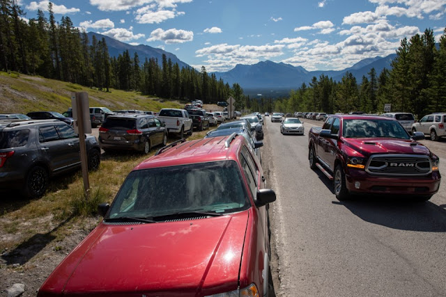
We love having adventurous friends come to town, as it encourages us to hit the trails.  Today we hiked to the summit of Fairview Mountain.  Whoever chose this name wasn't very good with adjectives ... or had never been to the summit.  The views were beyond breath-taking.  We couldn't get enough of looking around and by the end of it, we grew very tired of saying "Wow."

This season's list of interesting trails didn't even include Fairview Mountain.


Starting from the Lake Louise parking lot meant that we had to be there early.  As this year the hiking (and the National Parks, in general) have been much busier, we needed to be at the trailhead by 8 am.  Luckily, we live just down the road.


Gaetanne, Brynn and Seán Murphy joined Kate and Sean for the hike

Up to the treeline and out towards the summit

Getting close to the steep parts.
Lake Louise ski hill is in the far background.

... and UP to the summit.

Do we really want to go all the way up there?

The sign pointing up to the summit is 200 metres vertically behind us.  Whew!

On the summit!  Whoo hoo!

Amazing panorama

2,671 metres up.  The parking lot is at 1,692 metres.

Lake Louise has the same distinctive colour, but looks very different from up here.

Cheeky chipmunk was looking for handouts.  She looks quite well-fed already.

Kate peers over the edge.  It's a long way down to the lake.

Looking southeast down the Bow Valley.

Starting back down after lunch.

More down, with spectacular views all around.

A picture from the viewpoint near the bottom of the trail.


We couldn't have picked a better day.  

Time is running out on our summer - we've noticed the evenings turn to night much sooner and there is a pronounced chill in the morning air.  We feel like we have made the most of this season.

Sunday, August 23, 2020

50km for a Milestone Birthday - 50° 52' 08" N 115° 21' 08" W


This is Gordon.  Gordon is turning 50.  Gordon thinks doing a 50km run is a fine way to commemorate this milestone.


This is a bottle of wine.  It is while drinking this bottle of wine that Gordon managed to convince Kate to join him of his 50km/50th birthday run.

Oh dear!


This is the course they decided to run.  From Buller Mountain, along the High Rockies Trail to Goat Creek then along the Goat Creek Trail to Bow Falls in Banff.  If you have your choice of routes, one with plenty of down is a wise decision.

Even so, 50km is a bloody long way to run!


This is at the starting point at Buller Mountain.  They are smiling, looking keen and eager.  Gordon still seems to think this is a good idea!


This is at Three Sisters Dam, almost at the halfway point.  Still standing, still smiling - this is a very good sign.  Or perhaps it is just the fresh shoes and socks that is causing the smiles?


This is at Bow Falls - the 50km mark.  A lap around the parking lot was required to reach 50km. Big smiles making the end of our first ultra-marathon distance.

Nailed it!


Note to self:
  • 50km is a bloody long way to run
  • Ignore Gordon the next time he comes up with a scheme to commemorate his birthday
  • 50km is a bloody long way to run
  • Ignore Gordon next time he come up with a scheme to commemorate anything
  • 50km is a bloody long way to run
  • Avoid red wine around Gordon when he is scheming
  • 50km is a bloody long way to run


Monday, August 3, 2020

Banff Virtual Half Marathon - 52° 12' 50" N 117° 09' 35" W

After a long winter of running on snow and ice, it was with great enthusiasm I signed up for the Banff Half Marathon.  It is always a gorgeous run - along Vermillion Lakes Road, out Highway 1A to a turnaround then back, a circuit of Banff to the finish line with cheering crowds.

Last year's finish - I obviously didn't pay for the official photo!

It is just glorious.  And it is a "destination run" so thousands come from all over the world to enjoy running in our beautiful Rockies.  Being fit and strong from a winter of running, I was looking forward to a great run complete with all the fanfare.  Then COVID struck our world...

So the Banff Half went virtual.  This means you have paid to run 21.1km by yourself on any course and, unless you finish the race and upload a time, no t-shirt for you! So dammit, after coughing up all that cash, I was determined to get the t-shirt.

But what course to run?  I considered Two-Jack Lake to Canmore along the Legacy Trail - a net downhill, some minor up and lots of flat.  I thought about running the actual course.  But when you can chose your own course, why run uphill at all or, if it comes to that, on the flat.  Let's find a course that is ALL downhill.  Being the Banff Half Marathon, I felt it was important to run it in Banff - or at least in the Banff National Park.

Now, just to step back for a moment for a lesson in geography .... the border between Alberta and British Columbia runs along the Continental Divide.  This is where the watershed on one side (BC) drains to the Pacific and the other (Alberta) drains to the Atlantic. Naturally, a high point.

Therefore, by starting my run on the Alberta/BC border at Sunwapta Pass, I could indeed run downhill for 21.1km.


So that is exactly what I did!


Now if only that t-shirt would arrive in the mail!

Tent Ridge Trailhead - 50° 50' 50" N 115° 21' 28" W

Long weekends in the mountains are for working folk.  

We have learned that Canmore locals try not to use the trails, rivers, pathways or any alpine niceties when the hordes from the flatlands are released from their jobs on Friday.  What used to be a trickle of outdoorsy people that came from Calgary has become, mid-COVID, a flood of locked-down freedom-seekers.  

Highway 742, a normally quiet road that happens to have a trailhead close by


If we have friends that suggest a weekend hike, we sigh deeply, then try to pick one of the non-popular trails ... and one that isn't just a slog through the woods.  I, personally, prefer a panorama to a idyllic lake nestled in a valley.  Also, instead of just summiting a single peak and having to turn around, I LOVE a chance to walk along a ridge, from peak to peak, coming down a different way so I don't have to see the same trail I just slogged up, in reverse.

As Kate has been doing quite a bit of trail running this year, she has inspired Gord to do a big run (a 50 kilometre trail run) prior to his 50th birthday in October.  In order to train for this big event (the trail run - NOT the birthday) they have been hitting the single track in training.  I will tag along, more often on my mountain bike but sometimes on foot.

Gord suggested we do a run this weekend and was happy for Kate to pick a good route.  Well, she absolutely hit it out of the park with her suggestion for today's outing.  Tent Ridge is not only a ridge walk, but a loop that means we are not backtracking at all.  The route was 11 kilometres of distance and 893 metres of vertical (usually a better indication of how hard the route will be than the distance).

We started early and met Gordon at the trailhead.  We decided to travel light, wearing trail running shoes (instead of hiking boots), lightweight running gear and minimal packs with only the essentials.  The weather cooperated, the flowers cooperated, the teeming masses cooperated (by staying away and leaving us with an almost empty trail) and luck cooperated by allowing us down the mountain with no injuries.  

Our route - click on the map above for the stats

300 metres up and 3 kms from the car, we reach the first alpine meadow.
In an hour, we will be on that ridge in the background.

About to leave the treeline and proceed up to the first peak

Scrambling up rocks but loving it

A marmot watched us, unconcerned, as we passed

Almost at the first peak.

Delicate alpine flowers, with the ridge we are about to walk along in the background


Kate looking over the Smith Dorrien Spray Valley

Looking across to the traverse from the first peak to the ridge walk

Heading down some light scree (loose pebbles)

Picking our way along the ridge

Gord and Kate along the far ridge

Fluffy cumulus clouds and a bit of wind kept us cool

Headed towards the last peak

Following an old creek down from the ridge into the trees
Can you spot the Blue-shirted Redhead?

The flowers were all out, including Indian Paintbrush

What a day!