Port Erin, Isle of Man - 54° 05' 09" N 04° 45' 52" W
We reckon all the good karma that Eyvan has built up over the years helped the sun to shine and the wind to blow in the right direction, giving us a marvellous passage to the Isle of Man. Thanks to Eyvan, our new, on-board photographer, we have a picture of the two of us putting up sails.
 |
| Great action shot! |
When you are on watch, you need to keep an eye on ships that are approaching. The chart plotter can make this seem MUCH more imminent than it is. Here is an example.
 |
| Yikes! Look at that ship RIGHT BESIDE US! It's a HUGE TANKER! |
 |
| Reality: not so scary. |
With that in mind, we looked ahead to a tidal race we were going to transit at the south end of the island - the Calf Sound. It could be very bumpy if we caught it at the wrong time in the tide cycle. As we approached, we could also see cliffs facing the sound and it was late afternoon - that could mean katabatic winds. We had planned to sail through, but lost our nerve about fifteen minutes away.
 |
| Can you see (on the red tracking line) where we turned into the wind to drop the main sail? |
Eyvan has turned out to be crew, rather than a passenger. He is fascinated by the ease of us moving and taking everything with us as we go ... all under wind power. Some thoughtful questions have come out about the mechanics of sailing and he has stepped up to help with tailing lines, grinding winches, even tidying up the deck and putting on sail covers when we dropped anchor in Port Erin. Wonderful how things just magically happened!
 |
| A keen deckhand. |
We dropped anchor in a bay that is very protected from the 20+ knots of easterly winds that had picked up from the ideal 12-18 knots that we had sailed across in. There was a submerging wharf that we were 200 metres away from. Our dinghy was lowered and into shore we went for our first reconnoiter.
 |
| An ideal spot. |
Port Erin is not one of the two major ports on the Isle of Man (those would be Douglas and Peel), but it has the reputation of the nicest beach on the island ... and we agree. There is no marina there and we see that as an advantage. Through our five days in Port Erin, we saw four other yachts drop anchor for a night and then move on. We didn't communicate with any of them - just happy to be co-existing with them for a bit in a pretty spot.
 |
| Fresh off the boat. |
Our first ventures ashore are usually to no more than 500 metres from the boat. We are there to check out the vibe of the place; availability of provisions (fresh milk for tea, bread, etc.); where to catch and what type of transportation is available; notice boards for events (concerts? festivals?) and if there is a pub or bakery that has good offerings.
By good luck, Port Erin is equidistant from Peel and Douglas on the bus system. A huge beach area spread out before us and wrapped around to ... a prominent tower/castle-looking thing on a cliff, right by the entrance to the bay. We decided that we would do a hike the next day. We headed back to Chinook to settle in, have dinner and finish off the evening with a game of Rummy-O.
 |
| If you visit, an evening of this may befall you, too. |
The walk/hike through town the next day was enhanced by sunny skies and a light breeze to keep us cool. The tides are up to seven metres difference here, so we brought our super-light dinghy right up on the wharf.
 |
| If we tied it to the end of the pier, the knot could have been five metres underwater when we came back. |
The sunshine continued so we hiked up to Milner Tower, a prominent landmark on the cliff above the bay. It was built in memory of William Milner who did many good deeds for the poor and fisherman of Port Erin. He made his fortune as a safe maker and thus the tower is in the shape of a lock and key. You can clambour up inside but it is not a home or a castle, merely a tribute with an awesome view!
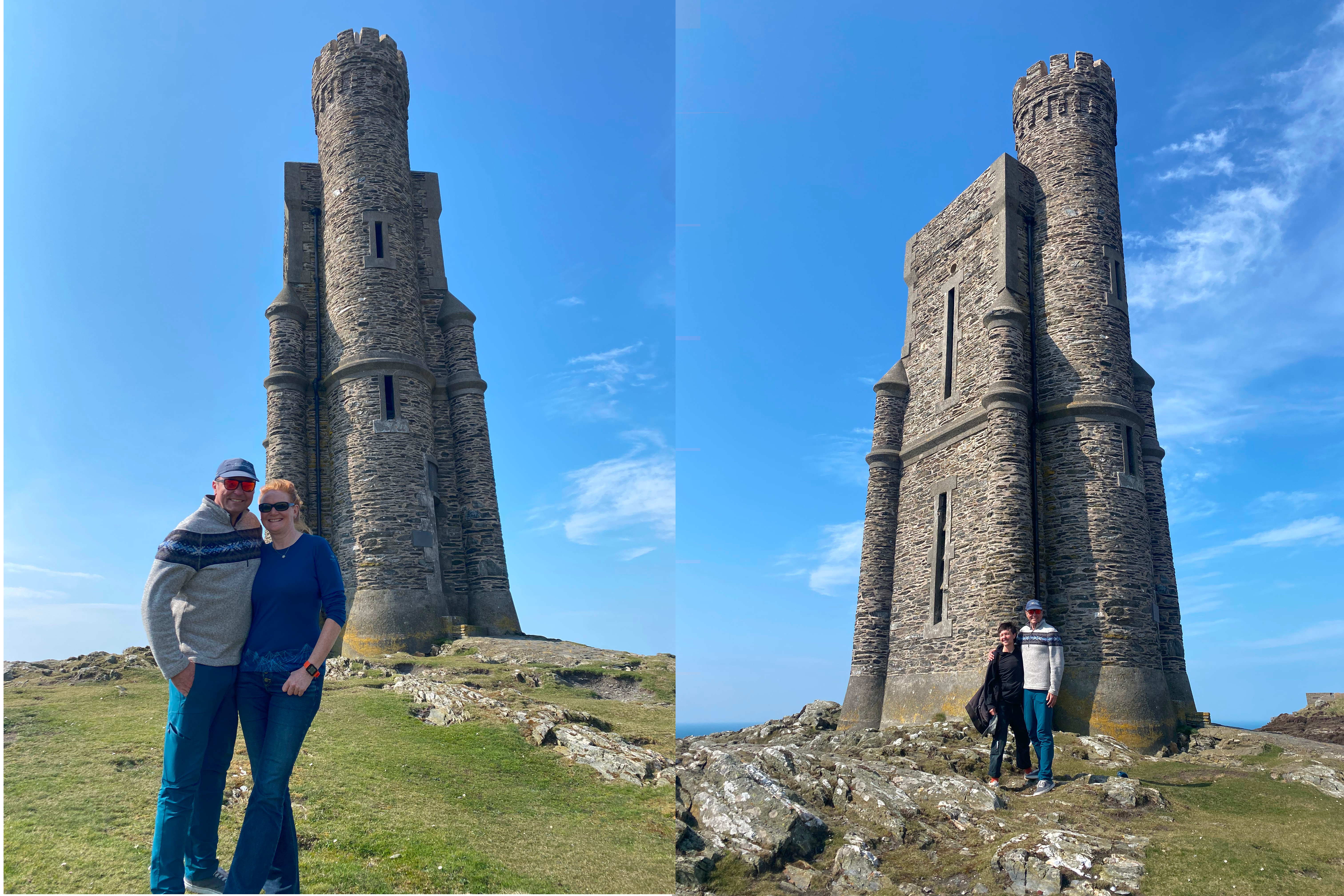 |
| Another photo of us together and one of the kiddo with Dad! |
Now, not only has Nancy been watching documentaries about steam trains in Wales, her viewing has extended to the trains on the Isle of Man. So off we went to explore them all.
 |
| Guess who is from The Isle of Man? (and it's not The Guess Who) |
First off, we were aboard The Isle of Man Railway steam train from Port Erin to Douglas, then the Douglas Bay Horse Tramway along the Douglas foreshore ... then The Manx Electric Railway to Laxey and finally, the Snaefell Mountain Railway. Phew!
 |
| Thomas?? This little engine puffed us from Port Erin to Douglas |
 |
| Mr Ed?? Completely unfazed by traffic, this chap clip-clopped us along the Douglas foreshore |
 |
| Tram?? The Manx Electric Railway took us from Douglas to Laxey |
On reaching the summit of Snaefell, the highest point of the island, guess what we did? Turned around and rode them all the way back to Port Erin!
 |
| 'I think I can...' This little train took us to the lofty heights of Snaefell |
Having gotten the trains out of our system, we sampled another form of public transport, the bus. Our destination was Castletown. We had passed through by train but were keen to give it a day's worth of exploration in its own right. Despite the sunshine, a rather arctic breeze had blown in so we were happy to spend our time in the relative warmth of the castle.
 |
| Castletown Harbour, complete with castle! |
This castle was fabulous, and we have explored many a castle! One of the things we really enjoyed was some of the spaces were decorated in accordance with the period they were demonstrating. The walls were adorned with tapestries, the floors with carpets and the rooms furnished. Still likely to be rather drafty but not nearly as bleak and damp as the stone ruins we are used to seeing. They even had examples of food. Even a cockatrice! This is a mythical creature with the head of a rooster and a serpent's body.was recreated by stuffing a chicken into the headless body of a piglet. And here we thought a turducken was pretty cool!
 |
| Whose turn to carve? |
 |
| The wallhangings, furniture, floor coverings and costumes gave an understanding of how the castle was used. |
 |
| This was much more indicative of what a 1600's castle 'audience' room would have looked like, rather than the usual unadorned stone walls that one would usually see as a tourist visiting these historic edifices. |
 |
| A very authentic 1600's era kitchen, but of course without the eight-year-old waif to turn the spit in the fireplace |
The next day, we felt another walk was in order ... but this time we would go south.
Under cloudless skies but with the stiff wind still blowing, we hiked along the rugged cliffs to Calf Point, overlooking Calf Sound. From our slight elevation, we could see the tidal race and the disturbed waters that we had come through.

 |
| Little Calf Sound (not to be attempted without local knowledge) with seals enjoying the sunshine |
 |
We cut overland on our way back to Port Erin and came across the village of Cregneash. Cregneash is a living museum dedicated to the preservation of the traditional Manx way of life.
We saw our one and only Manx cat here!
 |
 |
| Note the stones that are used to tie down the thatch. Not windy here at all! |
 |
| Notice the monogram on the Royal Mail letterbox? Well, that was a few monarchs ago.... |
As we walked along the road, sights seen (or so we thought), standing by the side of the road was a simple sign with the words "Mull Circle" an arrow pointing up the hill. What could it be up there? Was a 'circle' worth an extra hundred metres of "up"?
In these parts, the answer is a resounding and pre-historic YES. Up the hill, in a farmer's field, was Meayll Circle, a burial mound that archeologists suspect dates back to 3500 BC. It is not quite the grand scale of Stonehenge, but this site is thought to be older. Wow.
 |
| Meayll Circle or Rhullick-y-lagg-shliggagh in Manx |
What was most remarkable is that you can walk up, around and through it. No one else there.
Looking out to sea and the islands beyond (Ireland), feeling the salty air blow past us, it wasn't hard to imagine the weight of importance that the Celts must have given this place to bury their tribal leaders here.
As full of fun as Port Erin and the surrounding countryside was, we knew we couldn't stay here all summer. There was another town on the Isle that we wanted to have a brief look at before we moved on ... and we did need to get Eyvan to Belfast to catch a ferry that he had booked.
After determining that it was faster to sail than catch the bus, we headed up the coast for a night at Peel.
 |
| As we approach Peel, could that be ... another castle? |
 |
| Along the waterfront from where be dinghy-ed in, we head towards the castle. |
We anchored in the bay and our first stop was Peel Castle! Armed with our audio guides (reminiscent in size and heft of an early 90's mobile phone), we learnt all there is to know about Peel Castle.
 |
| Peel Castle by audio guide |
 |
| Yep, the boat is still there! |
 |
| In full tourist mode ... complete with selfie-stick and audio guide! |
 |
| One street back from the waterfront. Clean, pedestrian friendly, interesting. |
 |
| Oh no! A music shop! Will Kate ever get these two out of here?? |
We did make it back to Chinook, but only after the shops began to close and our tummies told us it was time dinghy back and cook dinner.
Tomorrow, we rise before the sun and sail for another country.
Sort of.
And please remember that Blogger posts your comment as anonymous if you don't have an account, so please sign off with your name so we know who you are!
Love reading of your adventures on the water and explorations on land. Paul C
ReplyDelete